SANTORINI
CALDERA
SANTORINI
SANTORINI
CALDERA
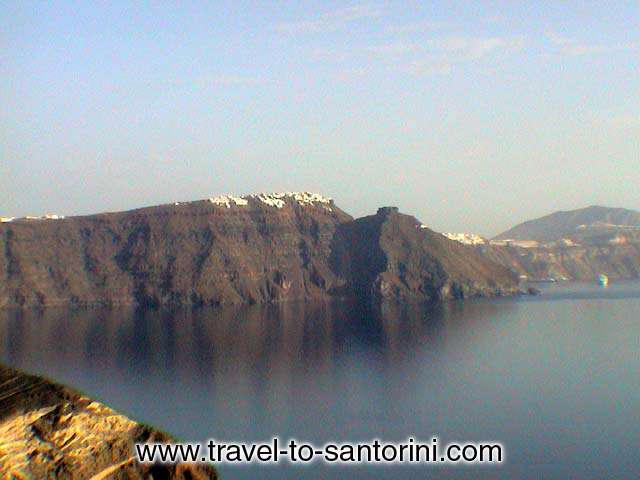
Caldera: the Spanish word for cauldron, a basin-shaped volcanic depression; by definition, at least a mile in diameter.
Up to about two million years ago, Santorini was a small non-volcanic island. Remains of this can still be seen at Mount Profitis Ilias in the southeast of the present island, which is made from non-volcanic limestone.
About two million years ago, volcanoes under the sea to the west of the island started producing magma, resulting in a number of small islands. Eventually (around 500,000 years ago) there were two giant 'shield volcanoes'. These are mountains in the shape of flat cones. These mountains united with the non-volcanic island to make one big island. Although neither of these mountains exist any longer, geologists have given them names. The northern mountain is called Mount Peristeria while the southern one is called Mount Thera.
About 200,000 years ago, things started hotting up. Mount Thera started to produce vast amounts of magma and ash, eventually completely emptying the magma chamber under the mountain. The structure of the mountain was not able to support itself and it went crashing downwards into the empty magma chamber, leaving a caldera - a wide, deep hole in the ground. This process was repeated in a whole series of eruptions over the next 200,000 years, with both mountains producing magma, collapsing, regrowing and collapsing again, each time deepening the caldera and eventually leaving the island in the shape it is today.
Caldera is nowadys covering approximately 32 square miles and the water's depth varies from 300 to 600 meters. At the western end of the caldera, we find the island of Therasia and an inhabitant island, Aspronissi. By taking a good look at those three islands we can easily distinguish a virtual borderline of what used to be there before the caldera was formed.
The height of the Santorini caldera is 150 to 350 meters. The length of the island from cape Exomitis to cape Mavropetra is 18 kilometres. Her width varies from 2 to 6 kilometres.
The shape of the present-day caldera has been changed many times during the centuries, because of the uninterrupted volcanic activity. |