SANTORINI
HISTORY
Medieval Settlements
SANTORINI
HISTORY
Medieval Settlements
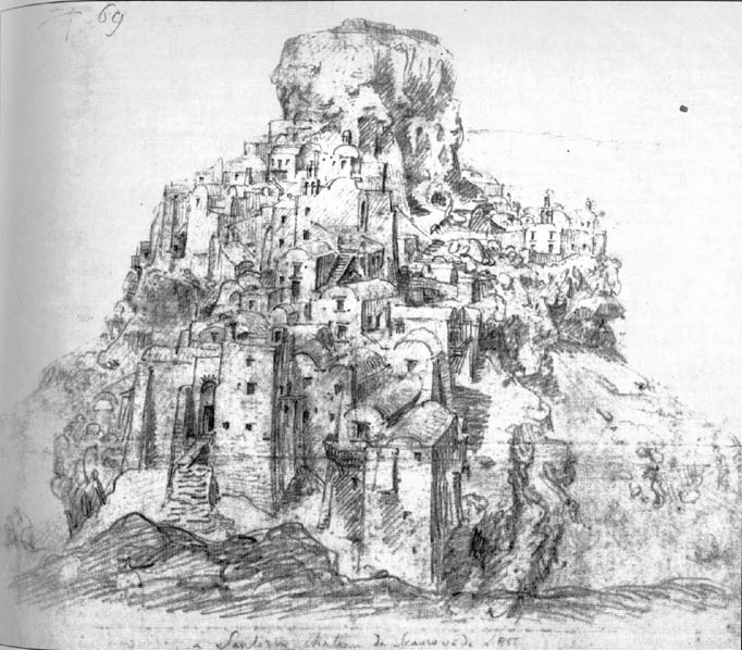
In the Middle Ages, Santorini settlements fell into two categories: the fortified ones, which were called Kastelia (castles), and the unfortified ones. Kastelia are mentioned in written sources from the early 15th century. Since the Byzantine times, pirates were the biggest problem faced by the Aegean islands, taking over the shores, imposing taxes and looting local communities. In an attempt to protect themselves, the people of Santorini built the Kastelia, where everyone -even vassals- took refuge when the alarm sounded. There is evidence of five such castles on the island since the Rule of the West.
The 5 Castles
Skaros, in the village of Imerovigli, was the most important castle, and that is where the Franks and their Lord came to settle. The second most important one was the Kasteli of the Epano Meria (Upper Side, i.e. Oia), which was called "of Aghios Nikolaos". The third one was in the area of Pyrgos (Tower), the fourth in Emporio and the fifth in the Akrotiri settlement. The last four ones were still in very good condition before the catastrophic earthquake of 1956.
The exact period when the Kastelia were built remains unknown (even though it is definitely placed between the 14th and 18th centuries), since no relevant inscriptions or historical evidence survive. What we do know, however, is that they stood in strategic locations, hard to approach by sea.
They looked a lot like fortresses, thanks to the morphology of the ground and the fortified houses of the outer perimeter, with few openings to the outside, practically forming a wall. On the inside, they were densely structured, with two or three-story buildings leaning against each other. These were long and narrow, with a common middle wall supporting a dome. Lower floors were partly built above the ground and partly rock-hewn underground. Streets were very narrow.
Nearly all members of the Catholic aristocracy of Venetians lived within these castles. The rulers had churches built in the entrances, dedicated to St. Theodosia, patroness of all Kastelia.
The Watchtowers (Goulades)
A typical feature of the Kastelia was the defensive watchtowers. They were called Goulades. They had a rectangular shape, many floors and thick walls. These buildings, either public or private, were the last refuge of the locals in case of an attack. There were Goulades inside the castles (as in Oia and Akrotiri) or outside (as in Fira and Emporio) so as the villagers could take refuge there.
The best preserved Goulas is that of Fira, known as Delendas' Goulas. It was built by the Bodgis' Venetian family before the depopulation of the castle in Skaros. Resident before the second world war was the French noble Compte de Simoni. Today it belongs to the family of Petros M. Nomikos.
Before the earthquake of 1956, the best-preserved castle was that of Pyrgos. Skaros in Imerovigli is destroyed; however, it served as prototype to build the other Kastelia on the island. During the Turkish Rule, when pirate raids subsided, construction was expanded beyond the defensive perimeter of the Kastelia, new settlements were founded and the capital was moved from Skaros to Fira. The expansion of the Kastelia and the creation of new settlements did not follow a specific plan. The morphology of the ground was the deciding factor and the roads connecting the Kastelia to the working areas and the production sites (such as the kánaves and windmills) were the main expansion routes. New communities were created around the main roads, as was the case with Fira, Firostefani, and Imerovigli.
The years 1700-1900 were crucial for the formation of structured communities, which were eventually urbanized, especially after the Greek Revolution in 1821.
In 1621 the Santorinians were forced to appoint representatives from the five Kastelia to negotiate with the pirates. During the last year of the Ottoman Rule, four rulers, joint commanders of Santorini, with corresponding seats in the four Kastelia, governed by issuing firmans, validated by a seal. This seal was unique. It was divided in four pieces and in order to be used all of them had to be assembled. Every commander had a piece. Therefore all decisions had to be unanimous.
* Sources: "Santorini: Society and Shelter, 15th-20th century", by Dr Dora Monioudi-Gavala/A publication of Lukas and Evangelos Bellonias Foundation.
"Thera, a march through time", by Antonis K. Kontaratos/Iliotopos Publications. |